|
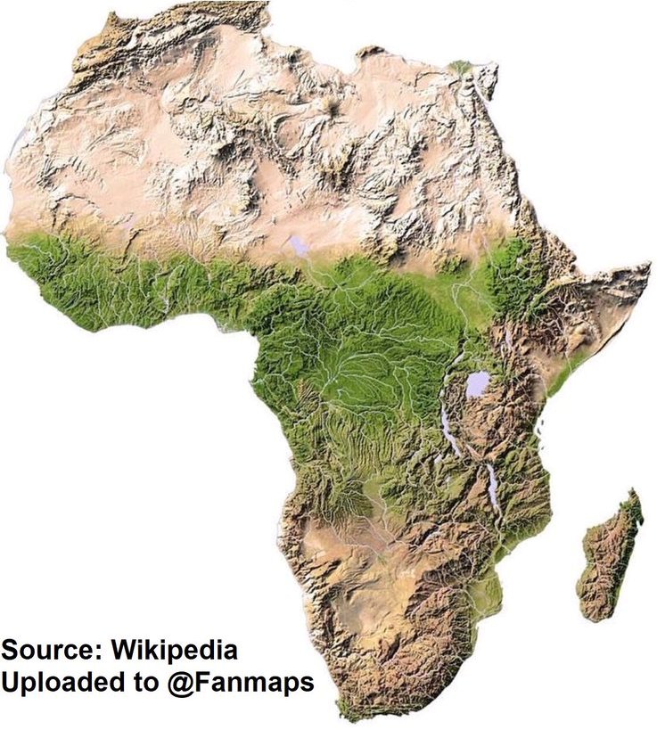
Reported by John-Peter Gernaat The final workshop, on Saturday 12 November, in the series of three observing different aspects of our world to gain a deeper understanding, was a look at the mountains of southern Africa with the focus being the mountains of the southern Cape and the Drakensberg. When one observes the continent of Africa and takes note of the mountain ranges the mountains related to the African Rift Valley run north-south across eastern Africa. The other two mountain ranges that become noticeable are the Atlas Mountains in the north west and the Drakensberg Mountains in the south east. They seem to bracket ( ) Africa. Something else becomes noticeable: Africa appears to have two protrusions. In the north west there are the Atlas Mountains that could be removed and the coastline of West Africa would curve smoothly to North Africa. Similarly the Western Cape from Velddrif to Witsand could be removed and the coastline would curve smoothly from the western Cape to the southern Cape. These protuberances are also interesting when one observes the vegetation which differs from the surrounding landscape. The Western Cape has the fynbos biome with is the most diverse biome and most unique in the world. Yet, there is a similar biome in the north west of Africa. Both of these areas experience a climate that we describe as Mediterranean, with a winter rainfall.
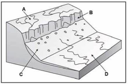
The Super-Continent of Gondwanaland, in its reconstruction, has a tectonic plate that sat between Africa and South America at the south western part of the ‘bulge of Africa’. This tectonic plate is known as the Azores plate and moved northward with the splitting of Gondwanaland. A part of the landmass on this plate fits well with the Atlas Mountains while another part may have broken loose and been ‘sucked’ southward as the Atlantic Ocean opened up to finally collide with the western Cape. This collision would in part explain the mountains of the Cape Fold belt. When one reads the geological literature and even tourist literature one is quickly struck by two very different explanations for the formation of the Cape Fold Belt. One is of a great basin into which sediments accumulated and before these sediments had fully hardened to rock the edges of the basin became steeper and steeper, caused by the weight of the sediment in the middle of the basin. As the edges became steeper the sediments slid down towards the middle of the basin forming the beautifully rounded folds seen in the many kloof cross cutting the Cape Fold Mountain ranges. The other explanation is of a collision of continental plates that pushed up the mountains. There is evidence of both processes visible in the geological record. Thus, it is possible to image that both processes were active at different times producing these mountains as the final result. The Drakensberg are a very different story. Typically, when a highland meets a lowland such as the coastal plain and an ocean, a very distinctive landscape arises. A sudden break in the high lying area (A) occurs forming a scarp face (B). The material that erodes from the scarp face forms a steep slope beneath the scarp called a talus slope (C). (Talus is the accumulation of debris in sheets or cones at the bases of rock walls.) Then follows the pediment (D) or foot of the highland. Looking at aerial photos of KZN from the coast, it becomes very clear that the Drakensberg are the scarp of the central highland of southern Africa and the talus slope and pediment of the coastal plain become visible. In the case of a true maintain there are at least two steep sides to a summit. The Drakensberg have only one steep side up the escarpment to the plains of the Free State. They are not mountains, but a scarp face.
0 Comments
Leave a Reply. |
Article Archives
December 2022
2023 - January to December
2021 - January to December 2020 - January to December 2019 - January to December 2018 - January to December 2017 - January to December 2016 - January to December 2015 - January to December 2014 - November & December 2013 - July to December 2013 - January to June 2012 - April to December Send us your photos of community events.
Articles (prefaced by month number)
All
|


 RSS Feed